Wolf Run Watershed - Trail of Springs - Lexington, Kentucky 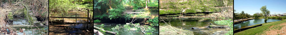
Home | Featured Springs | Project Partners | Project Activities | Spring Research | Register Your Spring | Contact Us
| FEATURED SPRINGS There are over 43 springs registered in the Kentucky Geological Survey database for the Wolf Run Watershed in Western Lexington, KY. Many of these springs are on farms and private property, but a number are in parks, greenways and visible from highway rights of way. All have interesting stories about their history, use and environmental significance. Please check the map linkto the right or the list below for information on our registered springs, if there is a spring you are aware of not on this list, you can have it added to the statewide registry. If you notice, many of the springs listed are "unnamed" We would like to name the, particularly the ones that flow all year round (Perennial Springs) If you are the property owner of one of these springs, or know of a historic name for one of the unnamed springs, please let is know. If you have a suggestion on a good, positive, catchy name for a spring, please suggest that too. (But please avoid off-color names, like Buddies Burble or Silly Seep :-) Notes about Springs on Private Property: We hope to involve private spring owners with this project in several ways:
|
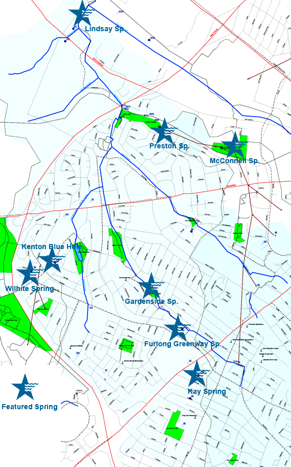
Wolf Run Trail of Springs Spring List found on our map
Name |
FLOW_TYPE |
LAT83 |
LON83 |
|
| 0 | MOBERLY Sp | PERENNIAL-featured | 38.030193 | -84.538642 |
| 11 | LINDSAY Sp | PERENNIAL-featured | 38.077299 | -84.552997 |
| 15 | MCCONNELL BLUE HOLE | PERENNIAL-featured | 38.054244 | -84.529940 |
| 74 | PRESTONS Sp | PERENNIAL-featured | 38.057021 | -84.541884 | 80 | WILHITE JAMES Sp | PERENNIAL-featured | 38.038160 | -84.563941 |
| 100 | KAY Sp | PERENNIAL-(Private) | 38.023966 | -84.536051 |
| 238 | GARDENSIDE Sp | PERENNIAL-featured | 38.035355 | -84.544381 |
| 16 | MCCONNELL RESURGENCE | PERENNIAL | 38.054244 | -84.531607 |
| 79 | KENTON BLUE HOLE | PERENNIAL-(Private) | 38.039660 | -84.561052 |
| 66 | Unnamed | PERENNIAL | 38.020910 | -84.537440 |
| 75 | Unnamed | PERENNIAL | 38.058410 | -84.548552 |
| 96 | Unnamed | PERENNIAL | 38.043133 | -84.536884 |
| 136 | Unnamed | PERENNIAL | 38.039244 | -84.559941 |
| 152 | Unnamed | PERENNIAL | 38.022578 | -84.512161 |
| 153 | Unnamed | PERENNIAL | 38.022022 | -84.511328 |
| 162 | Unnamed | PERENNIAL | 38.070355 | -84.556330 |
| 247 | Unnamed | PERENNIAL | 38.068688 | -84.557719 |
| 4416 | Unnamed | PERENNIAL | 38.068715 | -84.543578 |
| 54 | Unnamed | SEASONAL | 38.025633 | -84.537718 |
| 55 | Unnamed | SEASONAL | 38.035633 | -84.526051 |
| 56 | Unnamed | SEASONAL | 38.042577 | -84.522996 |
| 68 | Unnamed | SEASONAL | 38.017299 | -84.538829 |
| 70 | Unnamed | SEASONAL | 38.047299 | -84.553830 |
| 97 | Unnamed | SEASONAL | 38.024521 | -84.551884 |
| 98 | Unnamed | SEASONAL | 38.021466 | -84.556884 |
| 121 | Unnamed | SEASONAL | 38.034244 | -84.512995 |
| 133 | Unnamed | SEASONAL | 38.026466 | -84.517717 |
| 141 | Unnamed | SEASONAL | 38.033410 | -84.554384 |
| 159 | Unnamed | SEASONAL | 38.033410 | -84.542162 |
| 187 | Unnamed | SEASONAL | 38.011478 | -84.526039 |
| 191 | Unnamed | SEASONAL | 38.019778 | -84.496638 |
| 194 | Unnamed | SEASONAL | 38.026877 | -84.556440 |
| 197 | unnamed | SEASONAL | 38.041377 | -84.524940 |
| 233 | Unnamed | SEASONAL | 38.045355 | -84.558274 |
| 395 | Unnamed | SEASONAL | 38.039660 | -84.561052 |
| 4409 | Unnamed | SEASONAL | 38.057799 | -84.542995 |
| 4410 | Unnamed | SEASONAL | 38.058604 | -84.543884 |
| 4411 | Unnamed | SEASONAL | 38.058410 | -84.544828 |
| 4412 | Unnamed | SEASONAL | 38.059577 | -84.548135 |
| 4413 | Unnamed | SEASONAL | 38.059799 | -84.548274 |
| 4414 | Unnamed | SEASONAL | 38.059632 | -84.547606 |
| 4415 | Unnamed | SEASONAL | 38.072299 | -84.548829 |
Data and Map information provided in part by the
University of Kentucky Kentucky Geological Survey
![]()
The Wolf Run Watershed Trail of Springs is an educational exploration of the ecology, history, water supply features
and environmental issues associated with the many springs and wet seeps we have in our watershed.The Wolf Run Watershed Trail of Springs is similar to the Kentucky Bourbon Trail
in that there isn't a physical path that goes from one point to another,
but a series of stops along a guided exploration.
Project Sponsors